Questions & Answers
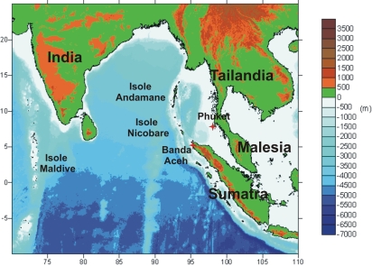 Fig. 1: Map of the coasts most badly hit by the seaquake of 26/12/2004. (Credit: Seaquake Research Team, Physics Dept, University of Bologna) |
Earthquakes the size of the one in Sumatra are linked to the high rate at which the plates move. In the area of Sumatra, the speed of movement is approx. 6-9cm/year, while in Italy it is a few mm/year. The biggest earthquakes ever seen in Italy were of a magnitude of about 7, such as the Strait of Messina earthquake in 1908 and the one that hit eastern Sicily in 1693. Historic records show that strong earthquakes capable of producing tsunamis (tsunamigenic) occur mainly in Calabria, eastern Sicily and in the Gargano area of Apulia, with faults tens of kilometres long. The fault which gave rise to the Sumatra earthquake broke for a length of 1000 km – almost the length of Italy. From historic documents and from what we know of the tectonic conditions of the Mediterranean, we can confirm that earthquakes on the scale of Sumatra cannot happen in Italy. |
- Is it true that Sumatra has moved 30 metres towards India?
The island of Sumatra is on the top side of the fault which gave rise to the earthquake. A fault is simply an area of contact between plates, when one plate subducts or slides under the other. In the case of Sumatra, the Indo-Australian plate slid under the Burma plate (see Fig. 1 in "The tsunami of 26 December 2004"). This shift averaged 15 metres on each side of the fault, with the result that Sumatra has moved 30 metres closer to the coasts of India and Sri Lanka.
- The earthquake of 24 December 2004 has shifted the earth's axis. What are the consequences for the climate?
The displacement of the earth's axis caused by the Sumatra earthquake can be explained by using the theory of the American astronomer Seth Carlo Chandler, who in 1891 discovered that the rotational axis of the earth oscillates around the inertial axis. The oscillation (known as the Chandler wobble) is due to the variation in the moment of inertia of the planet linked to its surface and internal dynamics – such as, for example, movements of ocean currents, movements in the mass of air and displacement in the earth's mantle at great depths. An observer at the pole "would see" the instantaneous rotational axis trace a circumference (in fact, it is an irregular curve) with a radius of a few metres over a period of approximately 433 days. Large earthquakes are one of the causes of such oscillations, given that they produce shifts of mass inside the earth. The Sumatra earthquake caused a sharp shift in the earth's axis, seen from the pole, of approx. 5-6cm. This shift is, however, of no significance if we compare it to the ordinary variations of the Chandler wobble. We can therefore conclude that such an event has not had any effect on the climate.
- What risks does a ship offshore face during a tsunami?
In the section "What is an earthquake?" we explained how the size of tsunami waves depends on the depth of the sea. We can see that waves in open sea are not very high – usually between a few tens of centimetres and one metre. Normal waves caused by the wind are much higher. Furthermore, the waves are very long, so the slope of the sea surface during a tsunami is too small even to be noticed. A ship positioned at a certain distance from the coast, or rather, at a point where the sea is quite deep, will not notice the passing of the wave and will not be affected by the catastrophe about to hit the coast.
- How high can the waves be when they hit the coast?
The height reached by the waves on the coast is called "wave run-up" in international scientific jargon. The run-up depends on the height of the wave out at sea and depends largely on the bathymetry near the coast. In the case of the earthquake of 26 December 2004, the wave reached the coast at heights ranging from 3 to 35 metres in the area of Banda Aceh, the town at the southern tip of the island of Sumatra (the worst hit area), 5 to 7 metres in the islands of Nicobar, and more than 5 metres in the Andaman islands. I n Thailand, they measured waves up to 10 metres high in the area of Khao Lak, and from 4 to 8 metres in the region of Phuket. On the coasts of central India, between latitudes 10° and 14°, the wave reached heights varying from 3 to 8 metres. A 1-metre high wave arrived in the Maldives. The wave even reached the coasts of Africa.